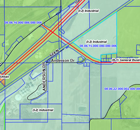
Project 218 Industrial Area - Rail Access
Property Description
Latitude/Longitude: 40.6086, -86.6329
Type of space: Heavy Mfg, Industrial, Light Mfg, Mixed Use
Min Size: 12 acres
Max Size: 100 acres
Last Updated: 2/6/2023
Site Details
For Sale: Yes
Sale Terms: Negotiable
Current Use: Agriculture
Zoning: Industrial 2 (I-2)
Zoning Authority: Carroll County Area Plan Commission
Site Description: Rail Served Industrial site
Address:
West of SR 218 off Hoosier Heartland Highway St. Rd. 25
Delphi, IN 46923
Available Documents
Rail Access
Rail Served: Yes
Rail Adjacent Site/Building: Yes
Distance to Rail: On Site
Rail Provider: Norfolk Southern
Interstate Highway
Interstate Name: I-65
Distance to Interstate: 19 miles
Local Highway
Highway Description: Property is adjacent to the new 4 LANE Hoosier Heartland Highway and on State Road 218.The Hoosier Heartland project involved replacing State Road 25, a two-lane rural highway constructed in the 1930s, with a new four-lane, limited-access highway that connects Lafayette to Fort Wayne, where it links to the U.S. 24 Fort to Port highway. A 12-mile stretch of this project – from Lafayette to Delphi – opened to traffic on Oct. 24, 2012. The remaining portion of the highway – from Delphi to Logansport – opened to traffic October 18, 2013. The 36-mile Hoosier Heartland project upgraded the old highway’s 81 at-grade street intersections, three at-grade railroad crossings, and more than 140 private entrances and improved access and safety while promoting economic development across Tippecanoe, Carroll and Cass counties.
Nearby Highway: Hoosier Heartland Highway and St Rd 218
Distance to Nearest Highway: Adjacent miles
Airport
Nearest International Airport: Indianapolis International Airport
Distance to Nearest Airport: 90 miles
Regional Airport Name: Delphi Municipal Airport
Distance to Regional Airport: 7 miles
Regional Airport Runway Length: 4000 ft.
Shipping
Closest Port: Port of Indiana-Burns Harbor
Distance to Port: 95 miles
Education
University Access: Purdue University: 28 miles / 35 minutes
Ivy Tech Community College/Logansport: 18 miles / 20 minutes
Utilities
Electric: Yes
Distance to Electric: New Feed to Site
Distance to Sub Station: .25 miles
Substation Size: 22 MVA
Electric Provider: CWREMC and WVP
Electric Volts: 12,470 Volts
Electric Amps: 600 Amps
KVA: 12,943
Power Phases: 3-Phase
Dual Feed: Yes
Natural Gas: Yes
Distance to Natural Gas: Adjacent
Natural Gas Provider: NIPSCO
Natural Gas Line Size: Infrastructure extensions will be required, but we do not anticipate any major issues.
Natural Gas Pressure: Infrastructure extensions will be required, but we do not anticipate any major issues.
Water/Waste Water
Distance to Sewer: Commercial TIF area. New sewer lines should be added in near future.
Sewer Provider: City of Delphi (future)
Water: Yes
Distance to Water: Commercial TIF area. New water lines should be added in near future.
Water Provider: City of Delphi (future)
Internet Communication
Telecom: Yes
Internet Connection: Yes
ISP: County is working on a fiber ring that will serve this area
- N&S RAIL-SERVED 12-100 acres (3 parcels)
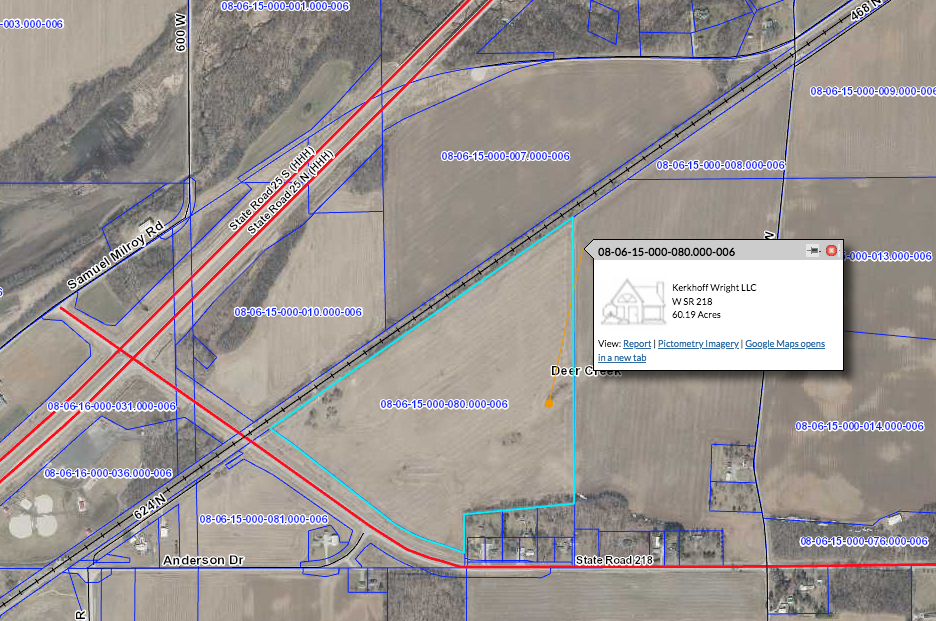
- 60-acres listed with 2 other properties available for sale (TRACK 1)
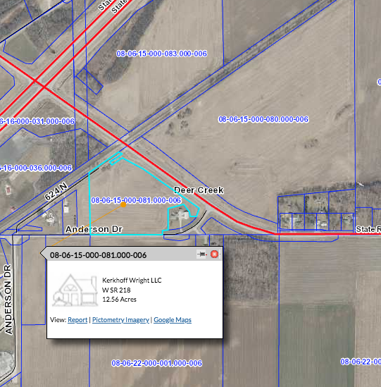
- 12-acre track available by same owner, across StRd218 (TRACK 3
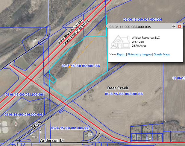
- 28-acres available on the other side of the rail, by different owner/partner. (TRACK 2)
- 1100+/- lineal feet of rail frontage
- Located in Commercial TIF
- Zoned I-2
- Situated adjacent to the property is a new 4 lane Hoosier Heartland Highway and on State Road 218 and just 20 minutes from I-65.
Latitude/Longitude: 40.6086, -86.6329
Type of space: Heavy Mfg, Industrial, Light Mfg, Mixed Use
Min Size: 12 acres
Max Size: 100 acres
Last Updated: 2/6/2023
Site Details
For Sale: Yes
Sale Terms: Negotiable
Current Use: Agriculture
Zoning: Industrial 2 (I-2)
Zoning Authority: Carroll County Area Plan Commission
Site Description: Rail Served Industrial site
Address:
West of SR 218 off Hoosier Heartland Highway St. Rd. 25
Delphi, IN 46923
Available Documents
- pdf Project 218 Overview (PDF)
- pdf Project 218 Rail Spur Plan (PDF)
- pdf Project 218 Utility Service Area (PDF)
Rail Access
Rail Served: Yes
Rail Adjacent Site/Building: Yes
Distance to Rail: On Site
Rail Provider: Norfolk Southern
Interstate Highway
Interstate Name: I-65
Distance to Interstate: 19 miles
Local Highway
Highway Description: Property is adjacent to the new 4 LANE Hoosier Heartland Highway and on State Road 218.The Hoosier Heartland project involved replacing State Road 25, a two-lane rural highway constructed in the 1930s, with a new four-lane, limited-access highway that connects Lafayette to Fort Wayne, where it links to the U.S. 24 Fort to Port highway. A 12-mile stretch of this project – from Lafayette to Delphi – opened to traffic on Oct. 24, 2012. The remaining portion of the highway – from Delphi to Logansport – opened to traffic October 18, 2013. The 36-mile Hoosier Heartland project upgraded the old highway’s 81 at-grade street intersections, three at-grade railroad crossings, and more than 140 private entrances and improved access and safety while promoting economic development across Tippecanoe, Carroll and Cass counties.
Nearby Highway: Hoosier Heartland Highway and St Rd 218
Distance to Nearest Highway: Adjacent miles
Airport
Nearest International Airport: Indianapolis International Airport
Distance to Nearest Airport: 90 miles
Regional Airport Name: Delphi Municipal Airport
Distance to Regional Airport: 7 miles
Regional Airport Runway Length: 4000 ft.
Shipping
Closest Port: Port of Indiana-Burns Harbor
Distance to Port: 95 miles
Education
University Access: Purdue University: 28 miles / 35 minutes
Ivy Tech Community College/Logansport: 18 miles / 20 minutes
Utilities
Electric: Yes
Distance to Electric: New Feed to Site
Distance to Sub Station: .25 miles
Substation Size: 22 MVA
Electric Provider: CWREMC and WVP
Electric Volts: 12,470 Volts
Electric Amps: 600 Amps
KVA: 12,943
Power Phases: 3-Phase
Dual Feed: Yes
Natural Gas: Yes
Distance to Natural Gas: Adjacent
Natural Gas Provider: NIPSCO
Natural Gas Line Size: Infrastructure extensions will be required, but we do not anticipate any major issues.
Natural Gas Pressure: Infrastructure extensions will be required, but we do not anticipate any major issues.
Water/Waste Water
Distance to Sewer: Commercial TIF area. New sewer lines should be added in near future.
Sewer Provider: City of Delphi (future)
Water: Yes
Distance to Water: Commercial TIF area. New water lines should be added in near future.
Water Provider: City of Delphi (future)
Internet Communication
Telecom: Yes
Internet Connection: Yes
ISP: County is working on a fiber ring that will serve this area
Aerial Map of Tract 1/Project 218 Property - Rail Access
Aerial Map of Tract 2/Project 218 Property - Rail Access
Aerial Map of Tract 3/Project 218 Property - Rail Access
Aerial Map of All 3 Tracts/Project 218 Property - Rail Access
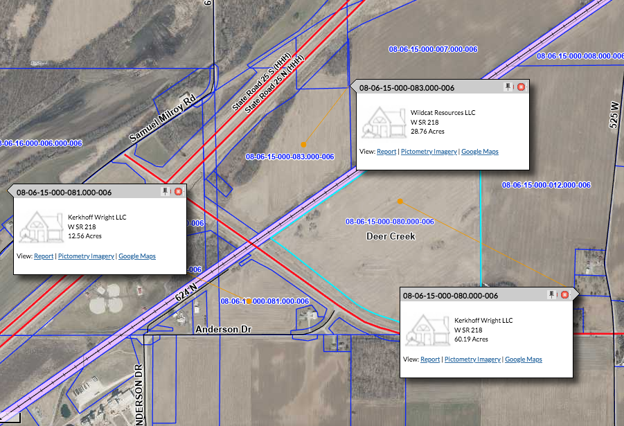
Property Zoning Map
